
Flight tracking and safety
Aviation Tracking
Track, message and see every flight. UAVs, fixed-wing and rotorcraft: the right tracking solution for every mission.
Know where every aircraft is, reach the crew from any phone and, when the mission needs it, see what the aircraft sees. KILAS, LECO-0698 and LECO-SOLARIS carry position, messaging, telemetry and live video over satellite and LTE, engineered for your aircraft.
- Built-in GNSS
- 1 Position per Minute
- Iridium Certus® 9704
- Browser-Based Messaging
- SMS & WhatsApp Worldwide
- 4G/LTE
- Avionics Networks Cloud
- Moving Map & QGC Compatible
- Live Video (LECO)
Departed base, 3 on board. ETA platform 14:35.
Sent from the cockpit browser · deliveredLanded on the platform. All normal.
Sent from the cockpit browser · deliveredChoose your level
From a position every minute to live video.
Every system starts with position and messaging. Choose KILAS to track and talk, or the LECO family when the ground team also needs continuous telemetry and live camera video.
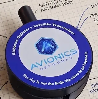
Track and message
KILAS
An Iridium Certus® 9704 puck with built-in GNSS. One position message per minute, free-text messaging from any browser, delivered to any SMS or WhatsApp number in the world. Optional 4G/LTE switches to real-time TCP/IP when in range. Positions and messages can flow through the Avionics Networks Cloud to your moving map or ground control software.
Explore KILAS →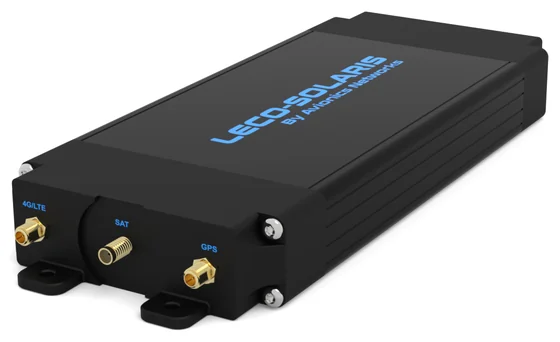
Track, telemetry and live video
LECO family
Everything KILAS does, with 4G/LTE built in and a TCP/IP satellite link for continuous telemetry, messaging and live camera video using our Video Espresso algorithm. Data flows through the Avionics Networks Cloud to your ground control software.
LECO-SOLARIS →LECO-0698 →| Capability | KILAS | LECO-0698 · LECO-SOLARIS |
|---|---|---|
| Built-in GNSS position | Yes | Yes |
| Satellite link | Iridium Certus® 9704 messaging, up to 100 KB per message | Satellite TCP/IP for continuous data (Viasat on LECO-SOLARIS) |
| Position reporting | One message per minute | Continuous |
| 4G/LTE | Optional: switches to real-time TCP/IP when in range | Built in |
| Free-text messaging from any browser, no app | Yes | Yes |
| Delivery to any SMS or WhatsApp number in the world | Yes | Yes |
| USB-C port for an external embedded device to control messaging | Yes | Yes |
| Works with moving-map and UAV ground control software, including ArduPilot and QGroundControl | Yes | Yes |
| Continuous telemetry | No | Yes |
| Live camera video with Video Espresso | No | Yes |
| Ground side | Avionics Networks Cloud or the Ground Control map | Avionics Networks Cloud |
Built for every mission
UAV, fixed-wing or rotor. Far from a cell tower.
UAVs, fixed-wing aircraft and helicopters work where the networks thin out: offshore, in mountains, over pipelines and at the scene. Tracking has to keep reporting there, and the people on the ground have to be reachable without special equipment. We have the right tracking solution for every mission.
Air medical
Operations sees every leg on the map, and the crew can message any phone on the ground from a browser, with no app on either side.
Offshore
A position every minute over Iridium, pole to pole and far beyond cellular range. LTE takes over again near the coast.
Utility and pipeline patrol
Track long patrol lines and send findings as text. On LECO, show the ground team live camera video of what the crew sees.
Law enforcement and public safety
Stream camera video to the ground with Video Espresso on LECO, over satellite or LTE, with position and messaging alongside.
Aerial firefighting
Position, crew messages and live fire-line video for the incident team. Firefighting connectivity →
Tours and charter
The office knows where every aircraft is, and pilots can send updates to customers and staff on any phone.
UAVs and optionally piloted aircraft
Works with the moving-map and ground control software built for UAVs, including ArduPilot and QGroundControl, with a USB-C port so the flight computer can send its own messages.
Any fleet
UAVs, helicopters, piston singles, turboprops and jets: one position a minute, worldwide, with messaging the whole team can use.
Messaging
No app. Just a browser.
Crew members message the ground from the device already in their pocket. There is nothing to install on board, and nothing for the person on the ground to install either.
- 1Join the Wi-FiAny phone, tablet or laptop on board connects to KILAS over Wi-Fi.
- 2Open the browserThe messaging page opens in the browser. Nothing to install, nothing to update.
- 3Type the messageFree text, to any phone number, from the cockpit or the cabin.
- 4Delivered worldwideOver Iridium, or LTE when in range, to any SMS or WhatsApp in the world.
Open to your systems
The right link, and the ground software you already use.
LTE when it can, satellite when it must. Position and messages reach phones, maps and ground control software without locking you into one screen.
On the aircraft
The link
On the ground
USB-C for your own equipment
An external embedded device can connect over USB-C and control messaging itself, from a mission computer to a sensor package.
Your moving map, your ground control
KILAS and LECO work with the moving-map and ground control software designed for UAVs, including ArduPilot and QGroundControl, through the Avionics Networks Cloud. For uncrewed, optionally piloted and crewed aircraft alike.
Cellular when it is there
KILAS has optional 4G/LTE and the LECO family has it built in. In range, they switch to cellular TCP/IP for real-time communication.
Engineered, not just installed
Designed for the aircraft it flies in.
Avionics Networks, a U.S.-based company, designs and manufactures its tracking hardware and engineers the antennas, power and mounting for each aircraft.
DO-160G Section 21
KILAS is qualified to RTCA DO-160G Section 21 for electromagnetic emissions.
Aircraft-specific integration
Antenna placement, power and mounting engineered by our team for the specific aircraft and mission.
One engineering team
Hardware, firmware, cloud and integration from one U.S.-based company, from the first call to the first flight.
KILAS and the LECO family are not certified emergency equipment. They do not replace an emergency locator transmitter or guarantee a distress response. Iridium and Iridium Certus are registered trademarks of Iridium Satellite LLC. WhatsApp is a trademark of WhatsApp LLC. ArduPilot and QGroundControl are open-source projects; Avionics Networks is not affiliated with or endorsed by them, by Ground Control or by other moving-map and ground control software makers.
One UAV, one helicopter or a whole fleet?
Tell us the aircraft, the mission and who needs to see it. We'll recommend KILAS or LECO and engineer the installation.